
By Roger Weber
It’s a story nearly half a century in the making: A connection to Dulles International Airport via Metro dates back to the public transportation system’s inception, during the LBJ administration, but planning of the line wouldn’t begin in earnest until the turn of the millennium. Now, some two decades later, that dream has finally become a reality with the opening of Phase Two of WMATA Metrorail’s Silver Line on November 15 of last year. Extending regional rail service about 28 miles west of Washington into Loudoun County, the project marks not only the largest expansion of the system in eight years, but also a major milestone for transit in the National Capital Region. Envisioned in countless forms since the 1960s, the now-completed line at long last connects downtown D.C. directly to its largest airport by rapid transit. The SOM-designed Washington Dulles International Airport station is among the six new stations now serving historically car-dependent communities, setting the stage for radical transformations through transit-oriented development (TOD).

The Silver Line extension is just the latest example of how transit-oriented planning efforts have spurred transformation in the region over the last half-century. For decades, expansions to D.C.’s Metrorail system have coincided with the growth of the nation’s capital from a sleepy government town into one of the nation’s largest metropolitan regions, with many of its most prominent regional centers clustered around Metro stations, including Rosslyn, Ballston, and Tysons Corner in Virginia, and Bethesda, Silver Spring, and Largo in Maryland. Since the system debuted in 1976, it has expanded from a single line with six stations to six lines and 97 stations, with a seventh—the purple line—set to debut in a few years. Over that time, the metropolitan area has grown from a population of under 3 million in 1970 to nearly 7 million today, stretching deep into both Maryland to the east and Virginia to the west, with Metro now serving five counties in addition to Washington itself.
The resulting system is among the most heterogeneous rail networks in the world, connecting a central business district to various longstanding centers, emerging hubs, major airports, greenfield development areas, and exurban bedroom communities. Metro unites an underground subway system and regional rail, connecting densely clustered stations in the urban core with widely spaced park-and-ride hubs in the suburbs.


Over the decades since Metro first opened, SOM has consistently helped to shape its evolution and impact on urban and suburban areas of all scales and demographics, delivering transit-oriented development around some two dozen different stations across the network. Unlike formulaic, one-size-fits-all approaches to TOD often deployed elsewhere, SOM’s work for and around D.C.’s Metro comprises innovative, bespoke responses to some of the most complex transit-oriented challenges in both urban and suburban conditions. As SOM has sought to advance the urban regeneration of Washington around Metro, flexibility has been paramount.
In many ways, our history of working on Metro reflects the evolution of TODs within the greater D.C. region, where transit access can simultaneously foster walkability and economic development in different ways, depending on the location. Broadly traveling from downtown towards the suburbs, the following examples represent just a few of the many facets of our multidisciplinary approach to transit-oriented planning and development.
Densifying the District
SOM’s long history in the Washington region spans several chapters guiding the region’s evolution around its rapid transit, exploring how transit can drive community formation and vice versa. In Washington’s downtown core, which has evolved from a car-oriented campus of primarily government buildings in the mid-20th century into a mixed-use hub integrated with Metro, SOM projects have helped increase density and land use diversity within a five-minute walking radius of 11 different downtown Metro stations. Even as D.C. has eliminated more than 100 surface parking lots since the arrival of rapid transit, its Office of Planning and the National Capital Planning Commission have considered even more ambitious proposals, such as the SOM-led 2013 District of Columbia Height Master Plan Modeling Analysis. Weighing the possibility of increasing citywide height limits around Metro stations, the range of approaches demonstrated how strategic changes to the 1910 Height Act could protect the historic skyline of the U.S. Capitol and other national monuments while permitting new development.


Meanwhile, at the street level, SOM has densified one of the busiest stations in the entire network with the build-out of the blocks surrounding the main entrance to Metro Center, a major interchange between its most-trafficked lines, Red, Orange, and Blue. SOM’s design for One Metro Center, completed in 2003, entailed not only building out a previously vacant parcel above the station entrance, but also delivering substantial Metro-adjacent density through the realization of a multi-story commercial building on top of a preexisting department store, taking advantage of air rights to reach the city’s height limit. The development of Metro Center endures as an especially creative and sensitive integration of historic and contemporary design in the District while supporting a crucial transit hub.
Urbanizing suburbia, one place at a time
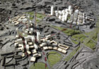
Of course, much of the Washington area’s steady and significant growth since the mid-20th century has resulted in car-dependent, sprawling suburban communities across Maryland and Northern Virginia. SOM has pioneered approaches to bring more sustainable, human-scaled development into these areas, built on principles of “transit-supportive design” in anticipation of a future with expanded transit networks. In 2005, SOM delivered planning and design guidelines for the urban transformation of Tysons Corner, an “edge city” with the region’s second-highest concentration of jobs, notorious at the time for its car-dependent configuration. The 30-year master plan applied smart-growth principles and a broad view of the civic and commercial benefits of sustainable city design, as well as an incremental development strategy that emphasized assets already present or planned for downtown and at key intersections. By 2014, as part of the Silver Line’s first phase, four Metro Stations were introduced at Tysons Corner, a turning point in the transformation of this formerly car-dependent suburb.

For the much smaller Seat Pleasant (pop. 4,500) in Prince George’s County, Maryland, SOM applied a similar approach in 2018 to help the majority-Black community plan stronger connections to the three existing Metro stations near the city. Our planning team engaged residents in a visioning process to articulate the community’s civic identity around a combination of transit accessibility, Black culture, and “smart cities” investments in civic operations technologies. Through the process, SOM helped envision a stronger civic role for Addison Road Metro station, from generating ideas for enhancing the blocks around it to connecting the station and the community’s business core.
Planning for potential
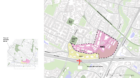
Building on this notion of transit proximity as a driver for a city’s long-term civic identity, SOM is currently working with the Town of Herndon, a mixed-income community of 24,000 residents—over a third of whom speak Spanish as a first language—for whom easy access to transit could significantly impact the suburb’s physical and cultural characteristics. Herndon’s new Silver Line station supports arguably the largest swath of unrealized land-use potential around any of WMATA’s 97 Metro stations, an area split between two overwhelmingly low-density and car-oriented jurisdictions. One side is surrounded by land owned by Fairfax County devoted primarily to parking and bus stops. On the other side, the land in the Town of Herndon is privately held by individual landowners comprising small office parks and light-industrial uses. Although new connections to make Herndon Station easier for people to access are underway, these communities are far from realizing the full experiential and economic potential of transit proximity.
Starting last year, the town asked SOM to help it imagine context-appropriate development and a stronger community relationship with the station that could complement County uses south of it. Examining 94 acres designated as Herndon’s “transit-related growth area” (TRG), the plan builds on a related proposal for high-density development immediately around the station. As opposed to typical transit-oriented development planning—which largely focuses on maximizing the economic potential for individual developers around a station—our plan examines a larger area encompassing as much as a 15-minute walk from the station, spanning 26 different land owners and approximately five percent of the town’s total land area. Drawing on principles of the “15-minute city” and “the 20-minute suburb,” the planning process seeks to transcend traditional TOD approaches by integrating them with community-planning tools typically applied in denser urban contexts, including planning for both public- and private-realm transformations simultaneously, and weighing how policy planning tools like zoning and design guidelines may influence change incrementally over many years.

To help generate consensus around the future vision for the TRG in a way that is authentic to Herndon, SOM is using physical and digital tools to engage a diverse range of stakeholders, neighbors, and residents. Through the plan’s website, residents can respond to survey questions in three different languages and access planning materials, while future outreach includes podcasts and surveys intended to understand how the TRG can foster community bonds in order to avoid creating an architecturally and culturally generic place. Envisioning a plan that meets the needs of the town will require creative strategies to leverage the role of transit in the post-pandemic era, maximizing Herndon’s appeal to prospective residents. In coming months, SOM will work with the town to bring a plan into focus as residents begin to enjoy access to the transit station as a component of their everyday lives.
Looking to the Future
Visitors and residents alike can now experience multiple dimensions of SOM’s comprehensive approach to transit-oriented design in D.C. and Northern Virginia. Anyone flying in to Dulles Airport can now take an affordable, one-seat, rapid-transit ride into the District of Columbia. Once the first seeds of investment come to bear in Herndon, many of those passengers boarding at Dulles Station may very well be on a short journey to their home or office.
As D.C. and Northern Virginia comprehensively realize stronger TOD, particularly in relationship to their airports, SOM has been at the forefront considering the role of architecture in helping to realize the full possibilities of this new spirit of transit-oriented community formation by maximizing the physical synergies between airport, rail, and neighborhoods. In 2017 SOM collaborated with the Crystal City Business Improvement District to develop a proposal for a dynamic new pedestrian bridge connection over the George Washington Memorial Parkway, which separates Crystal City, Virginia, from Ronald Reagan National Airport. Alongside emerging neighborhood redevelopment planning, the connection is a key component of National Landing, the re-branded, re-envisioned incarnation of Crystal City as a mixed-use transit-oriented community with direct pedestrian connections and multimodal transportation access to the airport. The vision for the new bridge will help to realize yet another dimension to the 15-minute city—airport access—through an architectural connection that is iconic yet sensitive to its context.

From Dulles Airport to Herndon, Virginia, to National Landing, seamless multimodal connectivity across the greater Washington, D.C., region is becoming a reality. Our TOD projects in the region are as diverse as the system itself, reflecting our longstanding commitment to developing creative, context-specific—at times even surgical—urban design interventions, tailored to the unique conditions of each station and development area. Whether it’s literally building on an existing retail hub to introduce mixed-use elements; taming an auto-oriented edge city; pioneering the concept of “transit-oriented growth”; or bridging the gap between underground tunnels and open skies, SOM continues to support WMATA’s effort to take on both local issues such as housing affordability and global ones such as climate change. The new Silver Line extension is just the latest example of SOM’s ongoing effort in supporting Metro and local municipalities in creating a more convenient, walkable, and attractive future for the region and its residents.
____
Roger Weber is an Associate Principal and Urban Designer who leads SOM’s Washington-based City Design Practice.